6. Policies, Proposals and Meeting the AAP Objectives
This chapter sets out the detailed policies and proposals which will deliver the vision, the objectives and the strategy of this AAP. The policies will be used to guide new development and supplement existing national, regional and local planning policies. The policies include:
Policy 1: New Housing Sites
Policy 2: Flood Risk
Policy 3: Property Improvements
Policy 4: Areas of Environmental Improvement
Policy 5: New and Existing Employment Sites and Retailing
Policy 6: Design Quality
Policy 7: Movement and Safety
Cross cutting themes such as health, sustainability and climate change are dealt with in each policy as appropriate.
The AAP Proposals Map is shown overleaf (Map 5). A plan showing the current Pendle Replacement Local Plan designations within the area is shown in Appendix 4 alongside a plan which shows what the Replacement Pendle Local Plan designations and the AAP designations will be after the adoption of the AAP.
Map 5: Bradley AAP Proposals Map
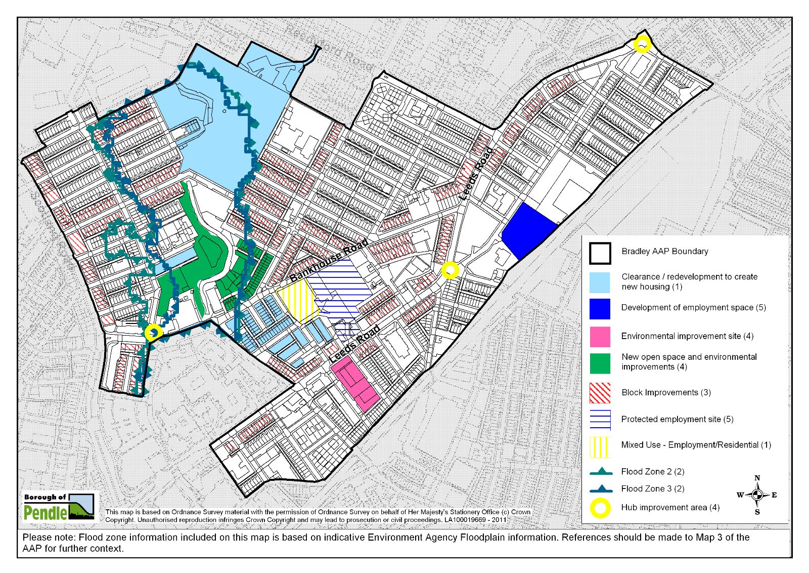
Key AAP Development Sites
The key development sites in this policy section of the AAP are as follows:
- Riverside Mills - proposed as primarily housing
- Part of Throstle Nest Mill - proposed as mixed use employment / residential
- Giles Street area adjacent to Throstle Nest Mill - proposed as housing
- Land off Cooper Street - proposed as housing
- Land to the east and west of Walverden Water - proposed as a new urban park
Contribution to AAP Objectives and Delivery
A summary of how each policy contributes to the overall objectives of the Bradley AAP and how it will be delivered is provided at the end of each policy. Further details about costs, delivery and implementation of the Bradley AAP are provided in Chapter 7. Details of how the plan will be monitored and reviewed are provided in Chapter 8.
Existing Section 106 agreements will be used to support the delivery of the AAP. Further information is provided in Chapter 7.
Policy 1: New Housing Sites
One of the key objectives of the Bradley AAP is to transform the local housing market.
To do this it identifies several key sites for new housing. Together these will accommodate a range of property types that help to extend and diversify both the choice and quality of housing in the area.
This new housing will contribute to improved community cohesion and the long-term sustainability of the area by providing housing that members of the local community would otherwise leave the area to acquire. It may also help to encourage a wider range of social, ethnic and income groups into Bradley.
New housing will also contribute to improvements in public health, help to create livelier and safer streets and reduce everyday running costs.
Housing Numbers
The AAP will provide new housing at three locations in the AAP area. Whilst development on these sites will primarily replace the 132 dwellings to be cleared within the AAP area, additional dwellings will be supported where they help to deliver the objectives of this plan and will contribute to the successful regeneration of the area.
Affordable Housing
The results of the Burnley and Pendle Strategic Housing Market Assessment (SHMA) (Fordham Research, 2008) indicates an overall need for 45% of all new housing to be affordable. However, the SHMA (at table 12.2) indicates that there is a lower need for affordable housing in Bradley when compared to the figures for the borough as a whole.
The SHMA also acknowledges that in practice, 45% is not a realistic target. A follow-up study was commissioned to consider the viability of providing affordable housing on different types of sites across the borough (Fordham Research, 2009). This indicated that in urban areas without subsidy or financial assistance a target for affordable housing could not reasonably be set under current market conditions.
Following on from the study that focused upon the viability of sites across the Borough, it was decided to engage Fordham Research to produce a further piece of work which would focus upon the viability of the 3 housing sites identified by the emerging AAP. The reason for this was to ensure that a robust and deliverable approach to the provision of affordable housing, that would be responsive to future changes in the housing market over the AAP timescale (up to 2021), was included in the final document.
Fordham’s report on the Bradley AAP area (2010) acknowledges the difficulty in setting affordable housing targets given the current state of the housing market and a lack of certainty over when and in what form the market will recover. However, the report concludes that a 20% affordable housing target is likely to be achievable with some variation in the amount of affordable housing grant and some increase in house prices. On the basis of the report’s recommendation, a 20% affordable housing target is proposed by the AAP however the policy acknowledges that where it can be shown that 20% is not economically viable a lower percentage of affordable housing will be accepted.
Where it is feasible to set an affordable housing target the SHMA shows that the greatest need in Pendle is for social rented housing (80%)(21) . There is some need for intermediate housing(22) (17%) and low cost market housing (3%).
The Council will work in partnership with a Registered Social Landlord (RSL) to provide affordable housing on sites which have been assembled using funding from the HMR programme.
Balancing the Housing Market
The SHMA also considers what type of housing is required to help balance the housing market at a ward level. For Bradley it shows that there is a need for the majority (51% or more) of new housing to have 3+ bedrooms. This is not surprising given the predominance of 2-up 2-down bedroom terraced properties in the area. There is also high local demand for larger family homes from the many Asian Heritage households in the AAP area.
Quality new homes
A key part of the Housing Market Renewal programme is to encourage better designed housing. RPL has established key standards that should be achieved in new development projects that it has helped to fund. These are: Building for Life (Silver), Code for Sustainable Homes (Level 3) and Secured by Design. The Council will encourage developments which achieve Building for Life (Silver) and Code for Sustainable Homes (Level 3).
With regard to Secured by Design, an accredited development will negate crime and safety problems which are prevalent in Bradley. It is therefore expected that new developments will achieve accreditation unless there are other design factors, for example the need to allow permeability through sites, which preclude this. Whether or not full accreditation is achieved the Council will expect applications to be supported by information indicating how steps to negate crime and maximise security have influenced the design of proposed development.
The quality and design of new housing will be important to the success of all new developments and will be informed by Policy 6: Design Quality and additionally, in the case of the Riverside Mill site, the approved Planning and Development brief.
Sites for new Housing:
1. Riverside Mills
The former Riverside Mills site has been vacant since 1999. It is derelict and has a negative impact on the area. The site is designated for employment use in the Replacement Pendle Local Plan (2001-2016). However, a commercial assessment of the site by Petty Chartered Surveyors (May 2007) concluded that:
"an industrial or commercial redevelopment scheme of this site is unviable due to several factors including competition from more favoured industrial sites within the area and the proximity of densely built up areas of housing along with poor road access".
Large scale employment uses would be compromised by the different levels on the site and poor access to it by road. However, whilst redevelopment of the site wholly for employment may not be considered viable, this would not preclude a mixed-use scheme where a small proportion of complementary uses would help to deliver much needed housing on this key site.
In this AAP it is intended that the large Riverside Mills site will accommodate a wide range of property types, significantly extending the choice of housing in the area. New housing will also open up the site helping to increase linkages between the Fleet Street and Regent Street areas.
The current link between Dalton Street and Crawford Street lacks activity. It is particularly unattractive to pedestrians after dark. New housing along these two streets will help to create a more attractive and safer link between the northern and southern parts of the Bradley AAP area.
It is understood from the Environment Agency and Pendle Borough Council's Environmental Health Team that a number of noise complaints have been received relating to the Norpol Recycling site adjacent to the Riverside Mill site. A noise survey should be submitted with applications for development on the Riverside Mill site to ensure that any adverse impact on future occupants is minimised.
As a former industrial site the Riverside Mill could potentially be contaminated. Planning applications for development of the site should be accompanied by a desk top study to assess whether the site is contaminated.
2. Giles Street Area and Throstle Nest
The housing adjacent to Throstle Nest Mill bounded by Bankhouse Road, Bradley Road East, Elm Street and Queen Street (collectively known as the Giles Street area) will be cleared and comprehensively redeveloped. This area suffers from particularly poor housing conditions, high vacancy levels and a degraded environment.
The Throstle Nest Mill complex presents a blank facade of stone walls to the surrounding area. Partial redevelopment of this site to provide a mixed use element along one side would present an opportunity to more effectively integrate the employment uses with the surrounding residential area. Remodelling the area in this way would involve the redevelopment of the three storey mill off Throstle Street for residential / employment use and the weaving shed would be demolished to provide new housing.
3. Cooper Street
New housing in this location, orientated towards the new park alongside Walverden Water will help to create an attractive edge to this new area of public open space. New housing overlooking the park will help to make it a more secure 'defensible space' reducing crime through better urban design.
Map 6: New Housing Development Sites

Policy AAP1 – New Housing Development
Part 1: New housing will be developed on the following sites (see map 6 above)in accordance with both the general criteria and any relevant site specific criteria included in this policy:
1. Riverside Mill (2.52ha)
The Bradley AAP allocates the former Riverside Mills site for housing. An element of mixed-use development will be allowed provided that it can be justified that:
i) A non-residential use is required to ensure that new housing is delivered and the site regenerated;
ii) The amount of any non-residential use will not detract from the strategic aim of diversifying the housing offer and meeting housing need in the Bradley area and delivering regeneration;
iii) Any non-residential use is complementary to any existing residential uses elsewhere on the site and would not prejudice the development of any other part of the site for residential use; and,
iv) Any non-residential use would comply with extant planning policy in terms of its location and in all other regards.
A noise survey should accompany planning applications for developments on the site to ensure that any adverse impact on future occupants from the use of adjacent industrial sites is minimised. Applications should also be accompanied by a desk top study to assess whether the site is contaminated.
2. Throstle Nest Mill and adjacent land immediately to the west
a) the Giles Street area (0.83ha) - i.e. the streets immediately west of Throstle Nest Mill; and
b) that part of Throstle Nest Mill west of Queen Street (0.26ha) to be re-developed as part of a mixed-use scheme.
3. Land off Cooper Street
Part 2: Residential developments proposed on other sites within the AAP boundary should comply with the general criteria listed below:
General Criteria
a) New housing should be built at an appropriate density which ensures that new development is successful in both respecting the urban form of the surrounding area and also diversifying the local housing stock, which is typified by a high density, grid-iron pattern of terraced housing. New housing should be built at a minimum density of 30 dwellings per hectare in accordance with Policy 20 of the Replacement Local Plan and to ensure the effective use of land. Houses should have gardens and garages or off-street parking particularly on the Riverside Mill and the Giles Street area sites.
b) The majority of new houses in development schemes should be larger (3+ bedrooms) dwellings to help meet the needs identified in the Burnley and Pendle SHMA (Fordham Research, 2008).
c) On each site within the AAP area where 15 or more dwellings are to be provided a minimum of 20% of these dwellings should be affordable housing units unless it is demonstrated on an ‘open book’ basis(23) that this would undermine the economic viability of the development. In such circumstances the maximum proportion of affordable housing units that can be provided viably will be sought. It is recognised that in some cases it may not be viable to provide any affordable housing units. Pendle Council will employ specialist consultants to provide independent third party advice on development viability. Developers may be required to pay for the cost of this independent assessment.
d) Development must incorporate Sustainable Drainage Systems (SUDS)(24) unless it can be proven that it would not be viable to do so.
e) Development should achieve Secured by Design accreditation unless there are any site specific issues affecting the design of a development which preclude this. In either event full details of steps taken to maximise safety and minimise crime in a development should be submitted as part of the design and access statement accompanying any planning application.
f) Biodiversity should be conserved or enhanced, through the inclusion of greenspace and trees within developments, where feasible.
Policy 1 contributes to the following AAP objectives:
Objective 1: Transform the housing market in terms of the housing types, tenure and quality. The AAP will introduce new housing on three key redevelopment sites in the core of the Bradley Priority Action Area. These sites include: the whole of the former Riverside Mill, the Giles Street housing clearance area adjacent to Throstle Nest Mill and the part of the Throstle Nest Mill site west of Queen Street, and a housing clearance site off Cooper Street. Both the strategic clearance of just over 130 terraced properties and the introduction of new houses on these sites will enable the housing market in the area to be restructured and transformed in terms of the quality and diversity of the housing offer. The Council will seek to ensure that the new development incorporates an element of affordable housing.
Objective 3: Facilitate the redevelopment of the former Riverside Mill site. In the AAP the Riverside Mill site will be redeveloped for new housing. This is a key redevelopment proposal which will secure the regeneration and re-use of this site.
Objective 6: Increase community safety and help reduce crime. New developments sites will be designed to promote community safety and to reduce the risk of crime. For example, Pendle Council will look positively on proposals which are ‘Secured by Design’ accredited. This will be further supported by a reduction in the number of vacant properties in the area and the creation of a vibrant, sustainable community in the longer-term.
Objective 9: Secure the productive use of vacant land and buildings to improve the urban environment. Policy 1 will secure the productive re-use of several pieces of vacant land and buildings to improve the urban environment.
Delivery
|
Outcomes: |
|
|
Indicators: |
|
|
Implemented by: |
Pendle Council, RPL, private developers / housebuilders, Registered Social Landlord’s. |
|
Means: |
Site allocations through Bradley AAP, Compulsory Purchase Orders (CPOs), development control, site planning and development briefs, development agreements, Section 106 agreements. |
|
Milestones: |
Assembly of sites, CPO’s made and confirmed, site development briefs agreed, planning permission granted. |
|
Funding: |
Housing Market Renewal (HMR) (see para 2.17), private sector, Registered Social Landlords. |
|
Timescales: |
Riverside Mill site – short-long term. Giles Street and Cooper Street sites – medium-long term. |
|
Risks: |
Failure of CPO to assemble sites, continued impact of credit crunch on new housing developments / housing market generally. Failure by developer to ensure that any redevelopment of the above site allocations will not be at an unacceptable risk of flooding in the future. |
|
Contingency: |
Considered greater mix of uses on the sites to help facilitate housing development. Try to secure additional funding. |
(Also see Chapter 7: Costs, Deliverability and Implementation).
Policy 2: Flood Risk
The Bradley AAP proposes residential allocations on the following sites:
a. Riverside Mill site,
b. Giles Street area (the streets adjacent to and west of Throstle Nest Mill),
c. Part of the Throstle Nest Mill Site (west of Queen Street),
d. Cooper Street site.
To satisfy part c) of the exception test additional flood risk reviews have been undertaken for each of the sites by JBA Consulting. These reviews have been considered by the Environment Agency who are satisfied that residential use could be accommodated safely subject to the flood risk mitigation measures identified in these reports (detailed in the policy below) and to be agreed at the detailed application stage. Applicants for development on sites a, b and c above will therefore be required to submit a Flood Risk Assessment (FRA) to demonstrate how flood risk will be managed in accordance with the policy overleaf.
It is important to note that the information produced by JBA provides a more accurate picture of actual flood risk for the four development sites than the Environment Agency's Indicative Floodplain Map. It is important that developers refer to this information and the maps produced by JBA which are shown at page 36-39 of the Technical Paper, in conjunction with the Environment Agency's information.
Both Hendon Brook and Walverden Water are designated as main rivers by the Environment Agency. The Environment Agency have also made it clear that their consent will not be forthcoming for any development over the Hendon Brook culvert, and development within 8 metres either side of the culvert will also be restricted, i.e. new buildings and private gardens will not be permitted.
To help reduce surface water flow rates Sustainable Urban Drainage systems (SUDs) such as soft landscaping, permeable pavements, green roofs, water butts, etc, should be incorporated in the design of new or regenerated development.
Policy AAP2 – Flood Risk
1. To ensure that any redevelopment of the following site allocations will not be at an unacceptable risk of flooding in the future, developers will be required to demonstrate the following:
a. Riverside Mill site
i. That any proposal within the area shown at risk of flooding is not classed as “Highly Vulnerable” in Table D2 of PPS25.
ii. That the proposal will include the removal of the sluice structure within the river channel adjacent to the site, and provide full justification where it is considered that this is not possible;
iii. That any proposal to redevelop the site will include the de-culverting of Walverden Water
iv. That the ground floor level of any building on site shall be set no lower than 124.5 metres Above Ordnance Datum (AOD). (25)
v. That the proposal will include full details of compensatory flood storage should the scheme involve any proposal to raise levels on site.
vi. That flood flow paths from upstream flooding have been included and that there is safe access and egress to any building(s) at risk during a 1 in 1000 year event.
vii. The flood resilience and resistance techniques that will be incorporated wherever possible in to the design of any building(s) within the area of the site considered to be at risk during anything up to a 1 in 100 year flood event.
b. Giles Street area
i. That any proposal within the area shown at risk of flooding is not classed as “Highly Vulnerable” in Table D2 of PPS25.
ii. That the ground floor level of any building(s) in the area shown at risk of flooding shall not be used for habitable accommodation(26) unless a flood risk assessment of a development scheme proves that the ground floor accommodation will not be unduly at risk of flooding in relation to flood risk issues affecting the site.
iii. That the proposal shall not include any raising of levels within the area considered to be at risk of flooding.
iv. That flood flow paths through the site have been provided and that there is safe access and egress to any building(s) at risk during a 1 in 1000 year event.
v. The flood resilience and resistance techniques that will be incorporated wherever possible in to the design of any building(s) within the area of the site considered to be at risk during anything up to a 1 in 100 year flood event.
c. Part of Throstle Nest Mill (0.8m max from Hendon Brook both in 1 in 1000 year events)
i. That any proposal within the area shown at risk of flooding is not classed as “Highly Vulnerable” in Table D2 of PPS25.
ii. That the ground floor level of any building(s) in the area shown at risk of flooding shall not be used for habitable accommodation(27) unless a flood risk assessment of a development scheme proves that the ground floor accommodation will not be unduly at risk of flooding in relation to flood risk issues affecting the site.
iii. That the proposal shall not include any raising of levels within the area considered to be at risk of flooding.
iv. That flood flow paths through the site have been provided and that there is safe access and egress to any building(s) at risk during a 1 in 1000 year event.
v. The flood resilience and resistance techniques that will be incorporated wherever possible in to the design of any building(s) within the area of the site considered to be at risk during anything up to a 1 in 100 year flood event.
2. A Flood Risk Assessment as set out in paragraphs 22-23 of PPS 25: Development and Flood Risk must accompany any application for residential development on all three above mentioned sites. Development within Flood Zones 2 and 3 on the above sites must:
a. direct less vulnerable land uses to those parts of the site at highest risk, i.e. locating public open space in most flood prone areas;
b. ensure any proposed layout is appropriately designed, i.e. aligning streets sensibly thus avoiding obstructing flow routes of shallow water;
c. define the minimum floor level for all habitable accommodation on site (in metres Above Ordnance Datum), and restrict habitable accommodation to first floor levels where the minimum floor level would make ground floor accommodation impossible or impractical given existing ground levels
d. consider proposed access and egress issues during any extreme flood event.
The AAP will also seek to restrict runoff at or above existing rates to ensure that the volume of surface water entering downstream culverts is not increased through the redevelopment of the AAP area. This could be achieved through Sustainable Urban Drainage Systems (SUDS) where appropriate and will include general ‘soft’ landscaping, permeable pavements, green roofs, water butts, etc, to be incorporated into the design of regenerated development.
Nb Environment Agency consent will not be forthcoming for any development over the Hendon Brook culvert, and development within 8 metres of either side of the culvert will also be restricted, i.e. new buildings and private gardens will not be permitted.
3. Where United Utilities indicate that there are properties at risk of sewer flooding in the AAP area:
a. Every opportunity should be taken to separate surface water, attenuate the surface water flow rate and discharge elsewhere than the foul combined sewer if possible
b. Sustainable Urban Drainage Systems (SUDS) type techniques including general ‘soft’ landscaping, permeable pavements, green roofs, water butts etc should be incorporated into the design of regenerated development;
c. in regard to flood risk in the south of the action plan area explore opportunities of disposing of separated surface water into Walverden Water. Run off should be attenuated to existing rates and should be uncontaminated.
Policy 2 contributes to the following AAP objective:
Objective 11: Consider the impact of climate change and, in particular, flood risk. The issues stage of the AAP preparation highlighted potential flood risks within the AAP boundary. Flood risk assessments will be expected to accompany any applications for new development on sites affected by this risk. The AAP proposes that part of the flood plain is redeveloped for open space.
Delivery
Policy 3: Property Improvements
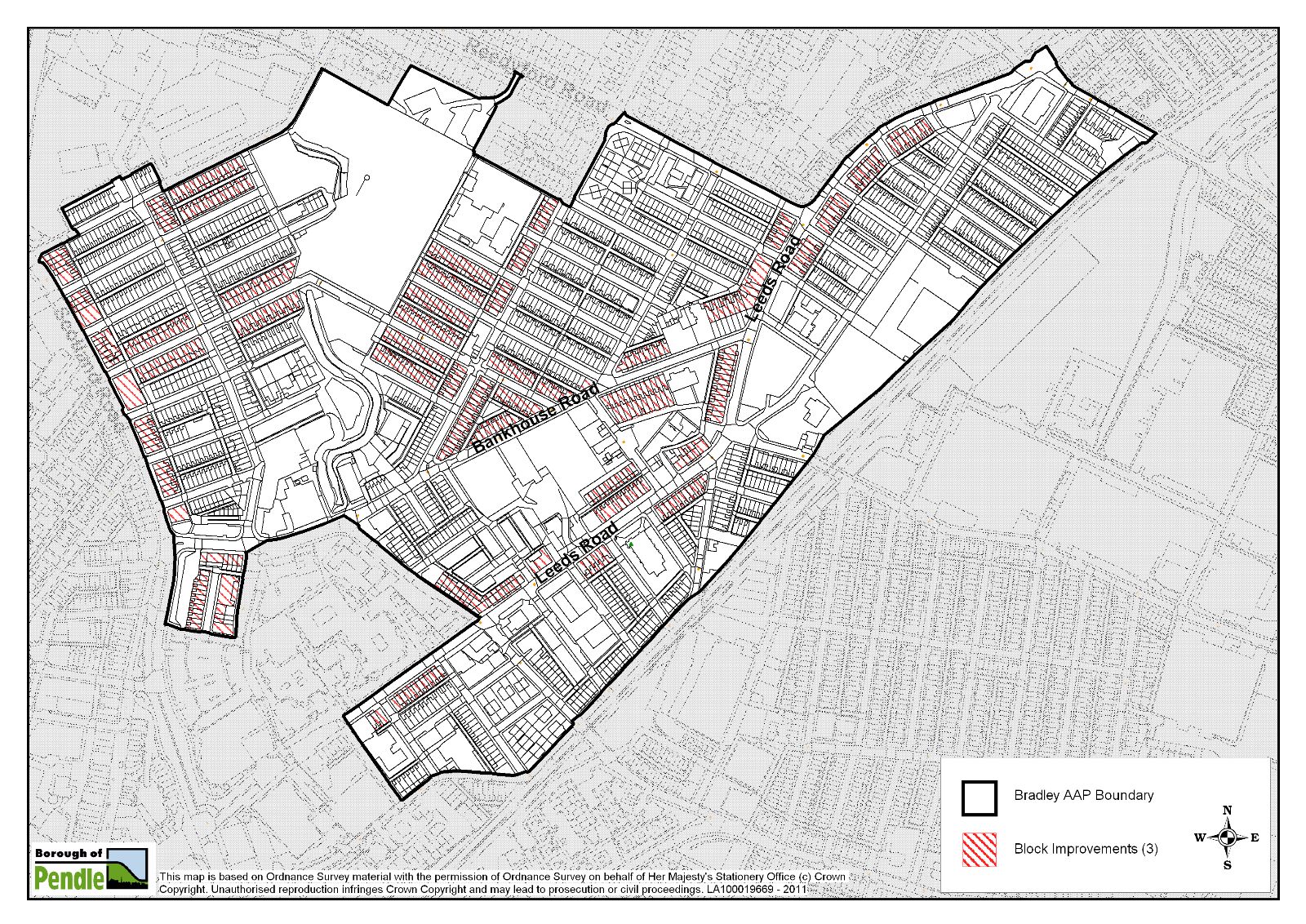
Block Improvements
In addition to delivering new houses within the AAP boundary, the AAP proposes a programme of external property improvements. The purpose of the improvement work is to help improve the condition of the properties and to enhance the image, desirability and perception of the area. This should help to raise confidence in the housing market and encourage wider private investment.
Blocks of properties have been identified as being suitable for improvements based upon their location, their condition or their state of repair (see map 7 below). Improvements are targeted:
i. along the key gateway routes within the area because of their importance to the overall perception and image of Bradley and Nelson more widely.
ii. around proposed redevelopment sites to provide an enhanced setting for new developments.
iii. in areas where the condition of the housing stock is particularly poor. Improvements to these properties could extend the life of the properties and improve the quality of life for those people living in them.
Map 7: Blocks identified for improvement
Improvement for Sale
To tackle this issue the Council has an 'Improvement for Sale' scheme which seeks to bring long term vacant properties back into use. The scheme involves the Council buying by negotiation the vacant property from its current owner. It is then fully renovated to Decent Homes Standard and sold, in the first instance to owner occupiers who are affected by clearance. The scheme is being and will continue to be used to tackle problem properties within the AAP boundary.
Policy AAP3 – Property Improvements
1. The Council will support the external improvement and repair of existing residential / commercial properties within the Bradley AAP area.
Properties which will form the focus of improvement work are located:
i. along the key strategic routes of Leeds Road and Scotland Road, the key east-west route of Dalton Street / Crawford Street (which links the Regent Street and Fleet Street areas). In addition the Oak Street area at the Bradley Road hub junction with Scotland Road and the principal local routes through the AAP area of Bankhouse Road and Regent Street are targeted;
ii. around proposed redevelopment sites (i.e. the Riverside Mill site and new park area south of it, Throstle Nest Mill and Giles Street area, and the Youth and Community Centre hub) to provide an enhanced setting for the new development;
iii. in areas where the condition of the housing stock is particularly poor i.e. the terraces adjacent to Bradley Primary school and in the Fleet Street area.
Improvements should be undertaken to a high standard of design. Detailed elements, for example, of windows / doors / railings should reflect the character of the property, whilst seeking to minimise future maintenance requirements.
2. Long-term vacant properties that are adversely affecting residential streets in Bradley will be targeted for acquisition and improvement under the Council's 'Improvement for Sale' scheme.
Policy 3 contributes to the following AAP objective:
Objective 5: Promote healthy living environments. Property improvements will help to create more healthy living environments by bringing some homes up to decent homes standard.
Objective 8: Improve the environmental quality of Scotland Road and Leeds Road - both key routes into Nelson Town Centre. This will be achieved through block improvements which will enhance these key gateways into the town.
Objective 9: To secure the productive use of land and buildings to improve the urban environment: Policy 3 will help to bring vacant residential properties back into use.
Delivery
|
Outcomes: |
Up to 500 properties improved. |
|
Indicators: |
Properties / blocks improved. |
|
Implemented by: |
Pendle Council. |
|
Means: |
HMR funded block improvement schemes delivered by partner contractor. Targeted acquisitions of long-term vacant properties through the 'Improvement for Sale' scheme. |
|
Milestones: |
Annual funding secured for block improvement work, property owners signed up to block improvements, contract let. Improvement for Sale properties acquired, improved and sold. |
|
Funding: |
Public, property owners. |
|
Timescales: |
Ongoing programme from short to long term. |
(Also see Chapter 7: Costs, Deliverability and Implementation).
Policy 4: Areas of Environmental Improvement
The Pendle Open Space Audit 2008 shows that in respect of ‘surpluses and deficiencies’ Bradley ward (the ward with the highest population in Pendle at 6735 persons) possesses the greatest deficiencies of parks, woodlands, natural green spaces, amenity green spaces and cemeteries of any ward in Pendle. This is particularly the case in the Bradley AAP area where there is only one equipped play area.
Walverden Water Corridor
New Urban Park
The only existing open space and equipped area for play in Bradley AAP area at Hey Street has long term recreational and leisure value and will be retained and enhanced.
Gateway Hubs
The gateway hubs contain a number of key community facilities such as the youth and community centre, parks, churches and shops. The Final Bradley Masterplan Report stated that improvements to these areas through a series of interventions including public realm and open space enhancements, selective building improvements and potential highways alterations could have positive impacts through relatively minor interventions, helping to lift the quality of Bradley. Improvements to these areas will be pursued, initially concentrating on the Leeds Road / Hildrop Road junction 'hub'. A 'Design and Regeneration Framework' has been developed to guide improvements at this particular hub and guidance will be prepared for the other two.
Policy AAP4 – Areas of Environmental Improvement
a) A new urban park will be created on (see map 8 overleaf):
- land east of Walverden Water;
- land west of Walverden Water.
b) Environmental Improvements will be encouraged and focused on:
- Walverden Water as it passes through the Riverside Mill site with a view to improving visual amenity, increasing biodiversity and improving the wildlife corridor along Walverden Water;
- commercial premises and land bounded by Leeds Road, Seldon Street and Harvey Street. The Council will encourage improvements to the appearance of premises and adjacent land with a view to improving both the visual amenity and commercial viability of this gateway site.
-
the three ‘Hub’ Improvement areas at:
- Bradley Road,
- Leeds Road / Hildrop Road, and
- Leeds Road / Walton Lane.
Improvements should be in line with the design and regeneration frameworks or appropriate guidance which will be produced for each;
c) The existing open space and equipped area for play at Hey Street will be protected for its long term recreational and leisure. The loss of this open space will not be permitted. The Council will support and encourage any enhancement schemes on this site.
d) Proposals for new housing on the sites identified in Policy 1 should seek to make adequate provision for new open space(28) on site. Where it is not possible or appropriate to provide open space on site the Council will instead require a commuted sum payment from the developer which will contribute towards the provision and future maintenance of the proposed new urban park in the AAP area.
Map 8: Areas of Environmental Improvement
Policy 4 contributes to the following AAP objectives:
Objective 2: Maintain and enhance the local shopping and business offer within the Bradley Priority Action Area, link local residents to job opportunities and improve the local skills base. Policy 4 will help to enhance the shopping frontage along Leeds Road and Scotland Road through physical enhancements along these routes.
Objective 4: Improve access to services and facilities, including publicly accessible open space and appropriate play provision. Policy 4 introduces a large area of new green / open space into the heart of the area. Linked with improvements to the Walverden Water Corridor this will create a focal point for the community.
Objective 5: Promote healthy living environments. Environmental improvements along Walverden Water, the creation of new open / green space, new housing development and improvements to existing housing will all serve to create a healthier living environment. Physical improvements will be complimented by services delivered by Surestart Bradley and Whitefield, East Lancs NHS, etc.
Objective 7: Extend and enhance the open space network through the creation of new open space and improvements to the river corridor. Policy 4 supports environmental improvements along the Walverden Water corridor plus the provision of a new urban park. The existing play area off Hey Street will also be improved.
Objective 8: Improve the environmental quality of Scotland Road and Leeds Roadboth key routes into Nelson Town Centre. This will be achieved through environmental and townscape improvements along these key gateways into the town. One of the key projects within the AAP will focus on improving key ‘hubs’ along these gateways. These are the busy junctions along these key routes, often where shops and other community facilities, e.g. the Youth Centre, churches, etc, are present.
Objective 9: Secure the productive use of vacant land and buildings to improve the urban environment. Policy 4 will help to secure the productive re-use of vacant land and buildings to improve the urban environment.
Delivery
|
Outcomes: |
0.87ha of new public open/green space to help address the identified deficiency in Bradley Upgraded equipped play area. Improved public realm and townscape. |
|
Indicators: |
New public green / open space, upgraded equipped play area. |
|
Implemented by: |
Pendle Council. |
|
Means: |
Development control, Section 106, Community Design Process, Hub Design Frameworks. |
|
Milestones: |
Funding for equipped play area / green space secured, Section 106 agreements in place, Community Design Events. |
|
Funding: |
Lottery, Section 106, other public. |
|
Timescales: |
Upgrading equipped play area – short term. New public green / open space – medium to long term. Hub Improvement Areas - short to long term. |
(Also see Chapter 7: Costs, Deliverability and Implementation).
Policy 5: New and Existing Employment Sites and Retailing
Bradley and indeed Nelson faces an ongoing challenge of addressing worklessness, prompting economic growth, fostering enterprise and increasing wage levels and prosperity. Sustainable economic growth and increased household incomes is a key element of a sustainable neighbourhood in Bradley.
Bradley Hall Road Employment Site
Trees will be planted on the northern and eastern boundaries and either side of the vehicular entrance to the employment site. The steep ground at the rear will be planted with shrubs, therefore making the best of limited landscaping opportunities on the site which will retain its high stone wall boundary to most sides. The site is adjacent to civic uses, existing industrial uses and the railway. Employment use on this site is therefore desirable and compatible with the wider area.
Throstle Nest Mill
The bulk of Throstle Nest Mill will be retained for employment use, though a mixed-use element at part of the site west of Queen Street would be supported in order to more effectively integrate the employment uses with the surrounding residential area. This would involve the conversion of the 3 storey mill off Throstle Street for residential / employment use and the weaving shed bound by Throstle Street / Bankhouse Road would be redeveloped for new housing.
In the case of the smaller north light mill and multi-storey mill in the western corner of the Mill complex, to the west of Queen Street, the study indicated that a variety of uses such as office, studio, residential or live/work may be suitable for this site. It is expected that a mixed-use redevelopment scheme would be made up of a combination of these use types.
Retail facilities on Scotland Road which serve the local community of Bradley and are part of the retail corridor leading to Nelson Town Centre are identified on Map 9. The local shopping frontage identified on the plan is protected by Policy 26 of the Replacement Pendle Local Plan which resists non-shopping uses and this retail protection would unaffected by adoption of this AAP.
Policy AAP5 – New and Existing Employment Sites and Retailing
1. Proposals for new employment development (B1, B2, B8) will be supported on the following site:
a) Land off Bradley Hall Road.
2. The following site will be protected for long term employment use (B1 or B2 / B8):
a) Throstle Nest Mill:
i) Proposals for development other than for business or general industry will be resisted on the part of the Throstle Nest Mill site east of Queen Street (hatched blue on map 9 overleaf). Change of use from B1/B2/B8 will only be considered where the criteria in saved Policy 22 of the Replacement Pendle Local Plan are met (see Appendix 3).
ii) The part of the site west of Queen Street (hatched yellow on map 9 overleaf) will be considered for change of use to mixed use (see para 6.59) in line with Policy 1 of this AAP.
3. A Local Shopping Frontage is designated on Scotland Road. Saved Policy 26 (see Appendix 3) of the Replacement Pendle Local Plan will apply.
Map 9: New and Existing Employment Sites and Retailing
Policy 5 contributes to the following AAP objective:
Objective 2: Maintain and enhance the local shopping and business offer within the Bradley Priority Action Area, link local residents to job opportunities and improve the local skills base. Policy 5 supports the creation of new employment space on the vacant site off Bradley Hall Road and the protection of the majority of the existing Throstle Nest Mill complex.
Objective 9: Secure the productive use of vacant land and buildings to improve the urban environment. Policy 5 will bring into use vacant land which will improve the environment.
Delivery
|
Outcomes: |
0.38 ha of brownfield land developed for employment uses. 0.43 ha of existing employment space protected. |
|
Indicators: |
New employment space protected, new employment floorspace complete. |
|
Implemented by: |
Private sector. |
|
Means: |
Development control. |
|
Milestones: |
Planning approval. |
|
Funding: |
Private sector. |
|
Timescales: |
Short-term i.e. 0-5 years. |
(Also see Chapter 7: Costs, Deliverability and Implementation).
Policy 6: Design Quality
In recent years, there has been much research into the value of good design(29). There is strong evidence that good design produces better economic, social and environmental returns for everyone involved, from residents and local authorities to developers and investors. Good design makes places work, giving residents more enjoyable lives, reduced crime levels, a more sustainable environment and greater civic pride,(30) for which there is a great need in Bradley.
RPL have produced a guidance book entitled 'Raising Design Quality in Pennine Lancashire' which is intended to assist professionals developing schemes in regeneration areas such as Bradley, to ensure excellent design is intrinsic to every stage of the development process (31).
Facets of Design
There are many facets of design which should be considered in the design of all new developments in Bradley. Good design will take into account other objectives that affect people's quality of life by:
- Helping to conserve nature.
- Improving energy efficiency and reducing greenhouse gas emissions and using water sustainably.
- Reducing opportunities for criminal activity.
- Helping to prevent or reduce the impact of flooding.
- Using sustainable local materials that add character and blend well with surroundings(32).
Artists and Places
According to a new report from CABE and Arts & Business, "too much development today lacks imagination and needs the creative, lateral thinking of artists" (33).
Pendle Council has commissioned an 'artist in residence' for Bradley who is based at the local primary school. They will help to facilitate the involvement of residents in the regeneration of the area and will work creatively alongside design teams for the new housing developments, public realm improvements, etc.
Respecting the Heritage and Character of place
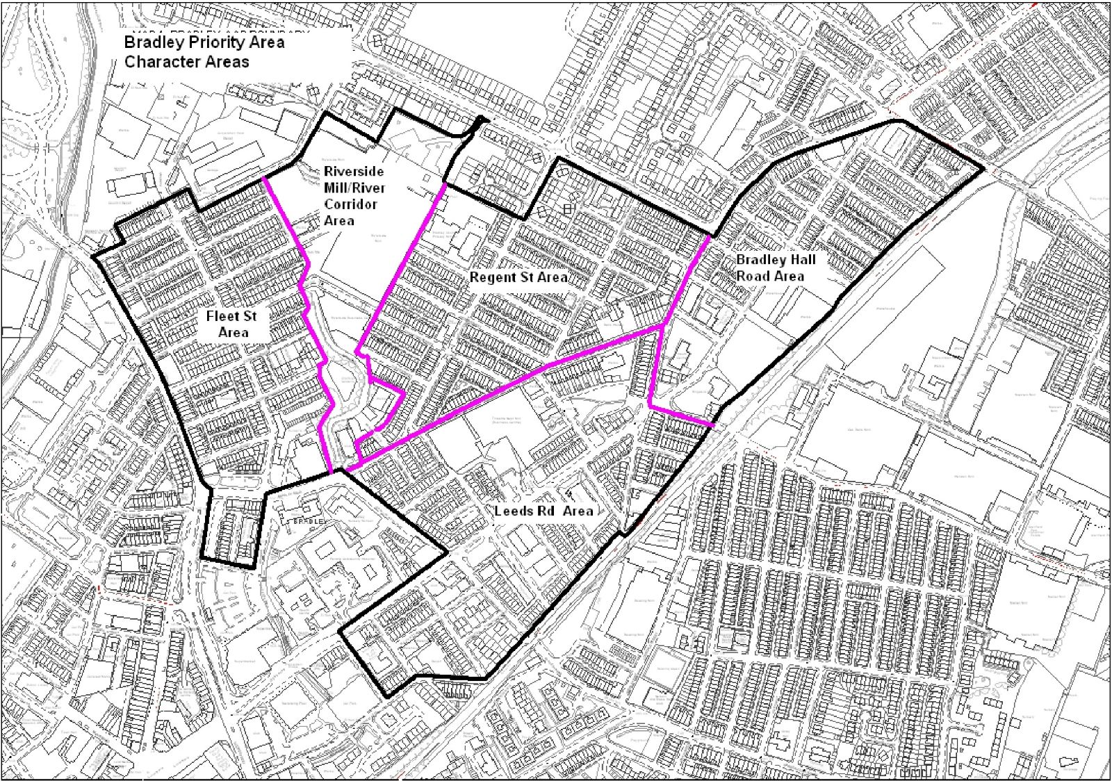
The policy has been prepared utilising the Bradley Intensive Urban Assessment carried out in 2006 to help guide the development of the AAP. The Intensive Urban Assessment split Bradley into several character areas (see Map 10 overleaf) based upon their physical built form and townscape. It provides the following summary guidance for each character area which should be considered in the design of any proposals for that area:
- Fleet Street area – this area is highly cohesive and consistent in terms of its layout, architectural character and housing quality. The cohesiveness of this area should be maintained were possible. Several terraces in this area have been group repaired and demonstrate how properties can be returned to their original condition in terms of external appearance. Additional selective group repair may be appropriate in this area.
- Riverside Mill and river corridor area – this area contains the most significant redevelopment opportunity in Bradley. Any redevelopment in this area should capitalise on the presence of Walverden Water, which flows through the former Riverside Mill site.
- Bradley Hall Road area – despite the fact that this area was one of the last areas within Bradley to be developed for terraced housing, the overall quality of the housing stock is poor. The area has been subject to environment improvements, but the removal of boundary treatments in some streets and the realignment of carriageways have lead to an erosion of the original character of the area. There are a number of redevelopment opportunities within this area, these include the Hour Glass Pub, the former Regency Cinema and Youth and Community Centre site.
- Leeds Road area – the Leeds Road area is dominated by the Throstle Nest Mill. The scale of the mill and the predominantly blank perimeter walls have a negative impact on the environment in this area and create a barrier to movement and connectivity. Also the demolition of Queen Street and Bank Street terraces has created some very untidy areas. This has resulted in a generally poor environment in the housing area to the southwest of the mill between Bankhouse Road and Leeds Road. Tackling the problems brought about by Throstle Nest Mill will be essential in improving the housing market in this area.
- Regent Street area - this area of Bradley comprises two distinct local environments. The area to the north of Crawford Street is well maintained with some alley-gating. The area to the south suffers from a poor quality environment, which needs to be tackled through demolition or group repair of the existing stock.
Policy AAP6 – Design Quality
Policy 6 is additional to Policy 13 of the Replacement Pendle Local Plan and any subsequent design policies in the Core Strategy.
Sections a - h of Policy 6 will apply in each of the Bradley character areas:
a) all proposals should demonstrate an assessment of surrounding design quality and character. This should take into account materials, massing, densities, heights, building to space ratios, buildings and spaces, social heritage, key pedestrian, cyclist and vehicular routes, landmarks, vistas and views, and, uses / tenure. It is expected that these should become part of any design and access statements which will be submitted with any planning application;
b) where proposals are related to changes to the public realm, open spaces and highways, colours and materials shall match those of the existing grit stone materials where possible. Materials should be robust and easy to maintain;
c) the principles contained in the Manual for Streets document (DfT & DCLG, 2007)(34) will be followed where projects involve changes to the highways and footway network. Higher quality materials should be used in those areas adjacent to where buildings of local architectural significance (as noted in the Intensive Urban Assessment July 2006) are located. New development should respect and enhance the existing grid structure of the Bradley area creating places that are easy to get to and move through;
d) for the design of shop fronts and replacement shop fronts, guidance should be sought from the Council’s adopted Design Principles SPD;
e) new housing should look to incorporate stone and slate in a high quality contemporary design. Layouts should embrace the specific topography of the site and should not be car / vehicle dominated. Care should be taken in regard to planting. Most of the existing terraces front onto the back of pavement and those with front gardens tend to be in the ownership of the householder. There is very little informal semi public space and new housing developments should look to reflect this. New developments should create places that are easy to understand, promoting recognisable routes, junctions and landmarks to help people orientate themselves. Clear and legible links to the town centre should be emphasised;
f) any affordable housing should be tenure blind (35);
g) the design of buildings and spaces should consider accessibility for all, including the young, old and disabled persons. Inclusive design should consider:
- The location of the building on the development plot;
- The gradient of the plot;
- The relationship of adjoining buildings;
- The transport infrastructure (36).
h) proposals which are not adjacent to the main roads are expected to reflect adjacent heights and massing;
i) all other new developments should look to make references to the surrounding built context and materials. Contemporary new design will be encouraged where it can clearly demonstrate that it will positively enhance character and amenity.
In addition Bradley Priority Action Area site specific design policies:
6j) interpretive information boards should be considered at strategic points within the proposed Riverside Mill development in order to provide an appreciation of and education about the past use of the site;
6k) quality landscape screening should be provided on the employment development site at the Bradley Hall Road frontage opposite All Saviours Church with particular reference to Policy 16 of the Pendle Replacement Local Plan.
Map 10: Bradley Character Areas
Policy 6 contributes to the following AAP objectives:
Objective 8: Improve the environmental quality of Scotland Road and Leeds Road - both key routes into Nelson Town Centre. This will be achieved through environmental and townscape improvements and new developments along these key gateways into the town which will be guided by Policy 6.
Objective 10: Promote quality new development that respects local character and contributes to local distinctiveness. Policy 6 seeks to achieve this and has been informed by the Bradley Intensive Urban Assessment.
Delivery
| Outcomes: |
Well designed, good quality buildings and public spaces. |
|
Indicators: |
Planning permissions for housing, public open space and public realm schemes. |
|
Implemented by: |
Pendle Council, private sector. |
|
Means: |
Site design briefs, development control, Design Review Panel (regional North West or local Pennine Lancashire review panels), Artist in Residence. |
|
Milestones: |
Schemes considered by relevant design review panel, planning permission granted. |
|
Funding: |
Private sector, public sector. |
|
Timescales: |
Short-long term |
(Also see Chapter 7: Costs, Deliverability and Implementation).
Policy 7: Movement and Safety
Connectivity and Access
Safety
Walverden Water
Car Parking
Cycling
Cycling is an inexpensive and healthy mode of travel and should be encouraged in Bradley since car ownership is relatively low and travel to work patterns show that the great majority of people in Bradley work within a very short distance from their home. Almost 45% of working residents work less than 2km from their home and over 20% of residents walk to work (ONS, 2001). Also the 2008 Pendle Health Profile (37) shows that the percentage of physically active children is the eighth worst in England. Encouraging cycling amongst Bradley children in particular could go some way towards addressing these health concerns.
In Map 11 (overleaf) existing cycle routes in the Bradley area are shown as a green line, existing pedestrian crossings as yellow squares and main destinations as red triangles.
Map 11: Existing Cycle Routes in Bradley
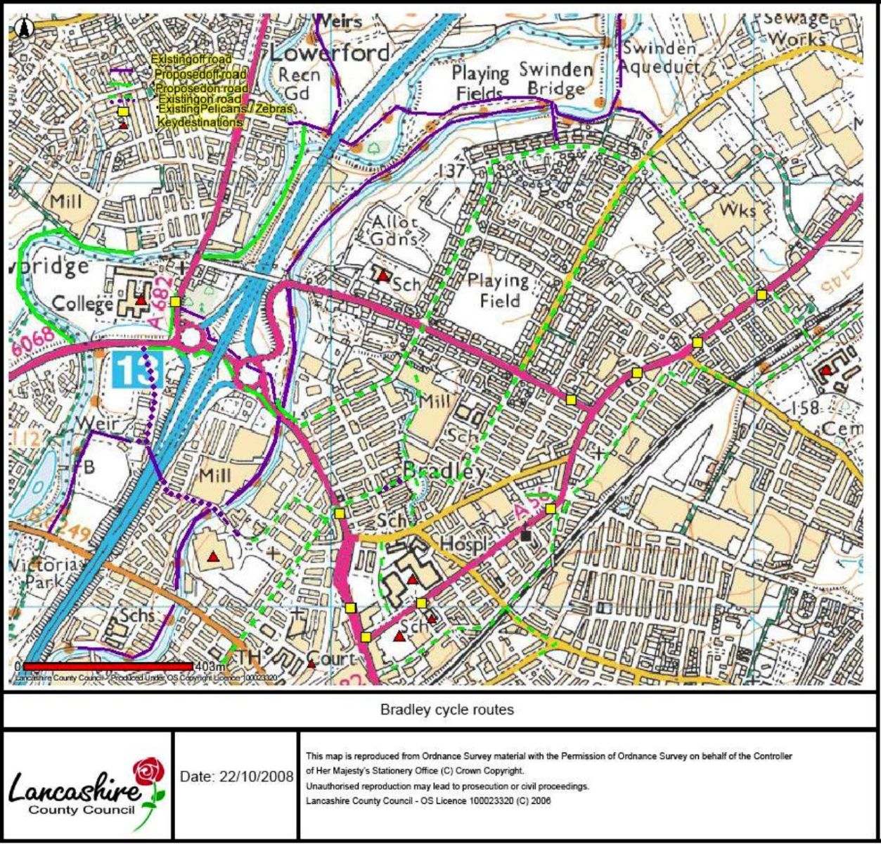
Map 12: Proposed Cycle Routes
.JPG)
Policy AAP7 – Movement and Safety
- Good access to key locations should be maintained as well as connectivity to the canal, both for walking and as part of the National Cycle Network.
- Cycling should be encouraged as an inexpensive and healthy mode of travel in Bradley where safe routes are able to be established.
- Prevention of pedestrian accidents in the area is paramount, especially on Fleet Street, Leeds Road, Hey Street and Regent Street. This should be achieved through appropriate highway treatments relating to any proposed new developments.
- Creation of new and improvement of existing play areas at Hey Street Park and the proposed new park either side of Walverden Water respectively will help keep children away from busy roads and dangerous junctions.
- Deculverting of Walverden Water as part of the landscaping of the redevelopment of Riverside Mill must be carried out with safety paramount both during works and on completion when in use as part of public amenity open space.
- Car parking needs for new housing and commercial developments should have regard to the Pendle Replacement Local Plan Policy 31 and its Appendix 2.
Policy 7 contributes to the following AAP objectives:
Objective 4: Improve access to services and facilities, including publicly accessible open space. Policy 7 seeks to improve movement and safety to key services and facilities.
Objective 5: Promote healthy living environments. Policy 7 promotes easier access to safe cycling routes.
Objective 6: Increase community safety and help reduce crime. Policy 7 seeks to improve the safety and movement of vehicles, cyclists and pedestrians in the AAP area.
Delivery
|
Outcomes: |
New cycling routes, reduction in pedestrian accidents. |
|
Indicators: |
2 km of new cycle routes created. Number of pedestrian accidents based on Lancashire Constabulary collisions records between 1/1/03 and 31/4/08 |
|
Implemented by: |
Pendle Council, LCC. |
|
Means: |
Working in partnership with LCC, informed by Cycling England Assessment. |
|
Milestones: |
Cycling routes agreed, funding secured. |
|
Funding: |
LCC, Section 106. |
|
Timescales: |
Medium-long term. |
Footnotes
21 Social Rented Housing is housing of a high standard which is provided at below market cost for households in housing need
22 Intermediate housing is priced at rents above those of social rent but below market price or rents. These can include shared equity and other low cost homes for sale, and intermediate rent.
23 The financial records for the proposed development should be presented in a fully auditable manner and made available to Pendle Council or its appointed consultants whenever reasonably required for purposes of verification in connection with the project.
24 For further information on SUDS visit: www.environment-agency.gov.uk/suds
25 124.5 m AOD is a conservative minimum floor level proposed as a mitigation measure in the JBA Flood Risk Assessment for the Riverside Mills site undertaken in 2006 for De Pol Associates. The minimum ground floor level of 124.5m AOD is required to provide at least 600mm freeboard between the predicted 1 in 100 year flood level plus an additional allowance for climate change effects.
26 Habitable rooms are considered to be all rooms other than halls, landings, bathrooms, toilets and small utility rooms.
27 Habitable rooms are considered to be all rooms other than halls, landings, bathrooms, toilets and small utility rooms.
28 for the purpose of this policy, this will include outdoor sports facilities, park land and equipped play areas
29 For example, The Value of Good Design, CABE, 2002; Economic Value of Urban Design, RENEW North West, 2007
30 Raising Design Quality in Pennine Lancashire, Elevate East Lancashire, 2008
31 Raising Design Quality in Pennine Lancashire, Elevate East Lancashire, 2008
32 Source: North West Best Practice Guide - North West Regional Assembly. May 2006.
33 'Artists and Places- Engaging Creative Minds in Regeneration' online at: http://www.cabe.org.uk/files/artists-and-places.pdf
34 see web link http://http://www.dft.gov.uk/pgr/sustainable/manforstreets/
35 Difficult to spot the difference between social affordable property and those sold to private buyers
36 see ' Inclusion by Design - Equality , Diversity and the Built Environment' CABE (2008) online at: http://www.cabe.org.uk/AssetLibrary/12403.pdf
37 Health Profiles are funded by the Department of Health and produced annually by the Association of Public Health Observatories.